In India, after Independence, the government formed a committee to find how the remote area and cities can be connected with each other by roads. The committee recommended plans of funds and research programs to develop roads for all-weather use.
The roads were initially divided into 4 parts such as:
>Natioanl Highways
>State Highways
>Major District Roads
>Village Roads
After many years reforms were made and Expressways were also added to the list and faster construction was assured.
As India is now on a stage where the infrastructure and facilities were much needed and thus new plans were floated. The new government made plans to cementing all the roads which also connects the village road. The New Project which is Bharatmala which means connecting the country link a mala (chain) via roads.
These roads will be connecting:
Villages to > Cities to > Market Place to > Ports and Airports
(this is my way to show the connectivity).
The Project:
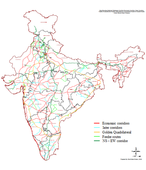
The Bharatmala Pariyojana a mammoth scheme was announced by Shri Nitin Gadkari in the presence of the Prime Minister Shri Narendra Modi Ji where the elements of the project such as building efficiency of freight and passenger movement across the nation by bridging the gap with critical infrastructure and developing Economic, Inter, Feeder, and National Corridors connecting Coastal and Portal roads and Green Field Expressway to various cities. The Bharatmala Pariyojana has drafted to built 34800 km. where it is aimed to build at least 18 km per day and efforts are made to make it 30 km per day. The project's first phase is proposed to be done before 2022.
 |
| Phase 1 Map Of Bharatmala Pariyojana |
This project is not just alone, the project will also be connecting to Sagarmala Project where the ports are being developed to have a better and large port for the shipping industry.
Due to a pandemic situation, many places have been affected but the good news is where the businesses got affected the government project was in full progress and the project will most probably not delay.


Comments
Post a Comment
Thank You for visiting, if you have any questions please feel free to ask: